


Here will WOC be decided: Map and terrain descriptions
Posted on | August 18, 2016 | Category: WOC news
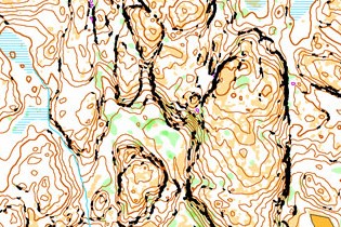
Automatically generated map of the Middle Distance area.
Since WOC took place in Finland in 2013, the world championships have visited Italy in 2014 and Scotland in 2015. Now Nokian Tyres World Orienteering Championships are back in Nordic terrain represented by the area around the Swedish cities Strömstad and Tanum.
World Trail Orienteering Championships take place in the same area at the same time.
Below you can read more about the different areas where it will be decided who can title themselves world champion. The map sections below are either an old map or an automatically generated map constructed by the organizers.
At the bottom, you find a map, which gives an overview of the areas.
| Distance: Sprint & Sprint Relay
Area: Strömstad city Mappers: Maths Carlsson & Per Bengtsson About: Urban area with some narrow streets, small forested areas and some areas of grass and lawns. Also hilly parts. Approximately 80% of the course lengths will be on hard surfaces. |
|
||
| Distance: Middle
Area: Tanum Mapper: Bo Herdersson About: Hilly terrain with many areas of bare open rock. Detailed contours with both larger and smaller cliffs. Marshes of varying size. Mostly very good visibility and runability. Some areas of thicker vegetation and younger spruce forest may reduce running speed. There are only a few paths and smaller roads in the competition area. |
|
||
| Distance: Long & Relay
Area: Strömstad East Mappers: Maths Carlsson & Per Bengtsson About: Hilly terrain with many areas of bare open rock. Detailed contours with both larger and smaller cliffs and reentrants. Marshes of varying size. Generally older forest with very good visibility and runability. However, the area includes a lot of heather and some logged areas and younger spruce forest, which may reduce running speed. Some larger and smaller roads cross the competition area and a network of larger and smaller paths. |
|


| Distance: PreO 1
Area: Saltö Mapper: Göran Olsson About: Pine forest with detailed curving. End of course: shore terrain with bare rock. Good hard forest path with roots appearing. |
|
||
| Distance: TempO
Area: Strömstad City Mapper: Maths Carlsson About: Park and forest terrain. Paved roads with some steep parts. |
|
||
| Distance: PreO 2 and Relay
Area: Tolvmanstegen Mapper: Göran Olsson About: Area with sparse pine trees around a windmill park. Mostly bare rock with moss, heather and marshes. Good dirt road, with some steep parts. |
|


All information about the events can be found in the latest bulletin.
A map of the different arenas used for WOC and WTOC. Press an area on the map to see which competitions take place in that area or press the bottom in the upper left corner for seeing a list.
|| Print page ||Search
IOF Main Sponsor
IOF Sponsors
World Championships


Other Upcoming Events


IOF Partners


